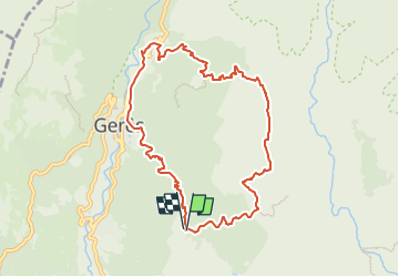
![](/images/other/stat-length.png)
![Trail On foot Vilar da Veiga - Trilho dos Currais - Photo](https://media.geolcdn.com/t/1900/400/a6786d5d-a36f-4450-a6ca-1c2fe6d07e05.jpeg&format=pjpeg&maxdim=2)
Trilho dos Currais
SityTrail - itinéraires balisés pédestres
Tous les sentiers balisés d’Europe GUIDE+
![Length](/images/other/stat-length.png)
![Max alt](https://static1.geolcdn.com/siteimages/upload/files/1508320355ic_sort_altitude_max_24dp.png)
![Uphill gradient](https://static1.geolcdn.com/siteimages/upload/files/1508320355ic_sort_den_pos_24dp.png)
![Km-Effort](/images/other/stat-length.png)
![Min alt](https://static1.geolcdn.com/siteimages/upload/files/1508320355ic_sort_altitude_min_24dp.png)
![Downhill gradient](https://static1.geolcdn.com/siteimages/upload/files/1508320355ic_sort_den_neg_24dp.png)
![Boucle](https://static1.geolcdn.com/siteimages/upload/files/16400158638029165_repeat_loop_refresh_sync_direction_icon.png)
![On foot](https://static1.geolcdn.com/sitytour/trail-icons/100.png)
4h00
Difficulty : Easy
![Scan this QR Code to open this trail in the SityTrail application](https://capi.geolives.com/qq0zvz2zws4bq2lad0pu/sitytour/trails/3110233/qr.png?size=200)
FREE GPS app for hiking
About
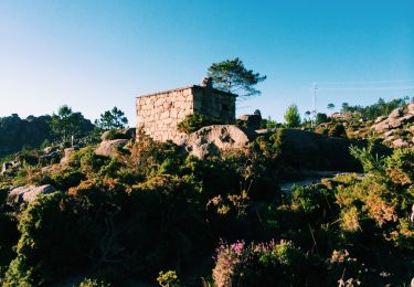
Trail On foot of 9.8 km to be discovered at North, Braga, Vilar da Veiga. This trail is proposed by SityTrail - itinéraires balisés pédestres.
Description
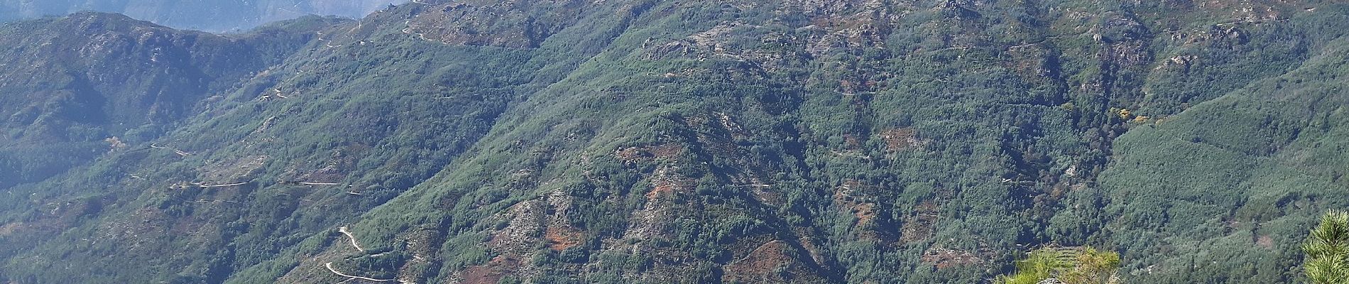
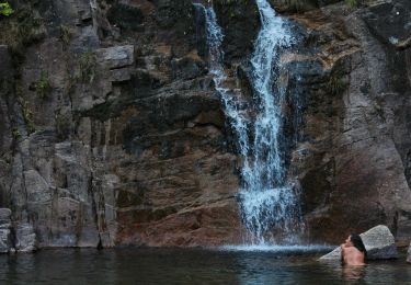
A rede de Trilhos Pedestres na Senda de Miguel Torga - Terras de Bouro, pretende ser uma homenagem a um dos maiores vultos da Literatura Portuguesa que durante mais de quarenta anos calcorreou estas paisagens e aqui escreveu alguns dos seus melhores poemas, e, por outro lado,um guia que possibilite, aos amantes da natureza, em particular, da Serra do Gerês, fruírem de um património natural e cultural de Terras de Bouro em toda a sua plenitude.
Website: http://www.cm-terrasdebouro.pt/rede_trilhos_pedestres/
Positioning
Comments
Trails nearby
![Trail Walking Rio Caldo - Sao Bento Peneda Gères - Photo](https://media.geolcdn.com/t/375/260/afdb6820-c09d-4a4f-9ce4-c6a20908e726.jpg&format=jpg&maxdim=2)
![Walking Walking](https://static1.geolcdn.com/sitytour/trail-icons/101.png)
Walking
![](/images/other/stat-length.png)
![](https://static1.geolcdn.com/siteimages/upload/files/16400158638029165_repeat_loop_refresh_sync_direction_icon.png)
![Trail On foot - Prados Caveiros - Ponte do Arado - Photo](https://media.geolcdn.com/t/375/260/c3737c89-c069-48fb-aa14-b6d0decde0b4.jpeg&format=jpg&maxdim=2)
![On foot On foot](https://static1.geolcdn.com/sitytour/trail-icons/100.png)
On foot
![](/images/other/stat-length.png)
![](https://static1.geolcdn.com/siteimages/upload/files/16400158638029165_repeat_loop_refresh_sync_direction_icon.png)
![Trail On foot - Trilho dos Miradouros - Photo](https://media.geolcdn.com/t/375/260/67787b80-0bc1-403f-b763-c40e2c660515.jpeg&format=jpg&maxdim=2)
![On foot On foot](https://static1.geolcdn.com/sitytour/trail-icons/100.png)
![Trail On foot - Geres Panorama - Photo](https://media.geolcdn.com/t/375/260/ea160227-6c4c-4682-8c18-8dc1c939e217.jpeg&format=jpg&maxdim=2)
![On foot On foot](https://static1.geolcdn.com/sitytour/trail-icons/100.png)
![Trail On foot Campo do Gerês - PE de Cabril - Photo](https://media.geolcdn.com/t/375/260/f94567c2-b8e0-4d89-8e2e-5044b6a81346.jpeg&format=jpg&maxdim=2)
![On foot On foot](https://static1.geolcdn.com/sitytour/trail-icons/100.png)
![Trail On foot - Trilho do Sobreiral da Ermida do Gerês - Photo](https://media.geolcdn.com/t/375/260/4396fc86-7aff-460e-854c-1bdd390a8c03.jpeg&format=jpg&maxdim=2)
![On foot On foot](https://static1.geolcdn.com/sitytour/trail-icons/100.png)
On foot
![](/images/other/stat-length.png)
![](https://static1.geolcdn.com/siteimages/upload/files/16400158638029165_repeat_loop_refresh_sync_direction_icon.png)
![Trail On foot Covide - Trilho da Cidada da Calcedónia - Photo](https://media.geolcdn.com/t/375/260/ba6670d2-c1ed-4b92-89df-48a590ecf026.jpeg&format=jpg&maxdim=2)
![On foot On foot](https://static1.geolcdn.com/sitytour/trail-icons/100.png)
On foot
![](/images/other/stat-length.png)
![](https://static1.geolcdn.com/siteimages/upload/files/16400158638029165_repeat_loop_refresh_sync_direction_icon.png)
![Trail Walking Campo do Gerês - Wikiloc - Calcedonia - Photo](https://media.geolcdn.com/t/375/260/ext.jpg?maxdim=2&url=https%3A%2F%2Fstatic1.geolcdn.com%2Fsiteimages%2Fupload%2Ffiles%2F1553511878bg_sport_marche.png)
![Walking Walking](https://static1.geolcdn.com/sitytour/trail-icons/101.png)
Walking
![](/images/other/stat-length.png)
![](https://static1.geolcdn.com/siteimages/upload/files/16400158638029165_repeat_loop_refresh_sync_direction_icon.png)
![Trail Walking Campo do Gerês - Wikiloc - PNPG (Campo do Gerês - Junceda) - Photo](https://media.geolcdn.com/t/375/260/ext.jpg?maxdim=2&url=https%3A%2F%2Fstatic1.geolcdn.com%2Fsiteimages%2Fupload%2Ffiles%2F1553511878bg_sport_marche.png)
![Walking Walking](https://static1.geolcdn.com/sitytour/trail-icons/101.png)
Walking
![](/images/other/stat-length.png)
![](https://static1.geolcdn.com/siteimages/upload/files/16400158638029165_repeat_loop_refresh_sync_direction_icon.png)